
A powerful 7.3 earthquake struck off Alaska’s coast near Sand Point, triggering tsunami
1. The 7.3-Magnitude EarthQuake That Shook Alaska: Timeline & Impact
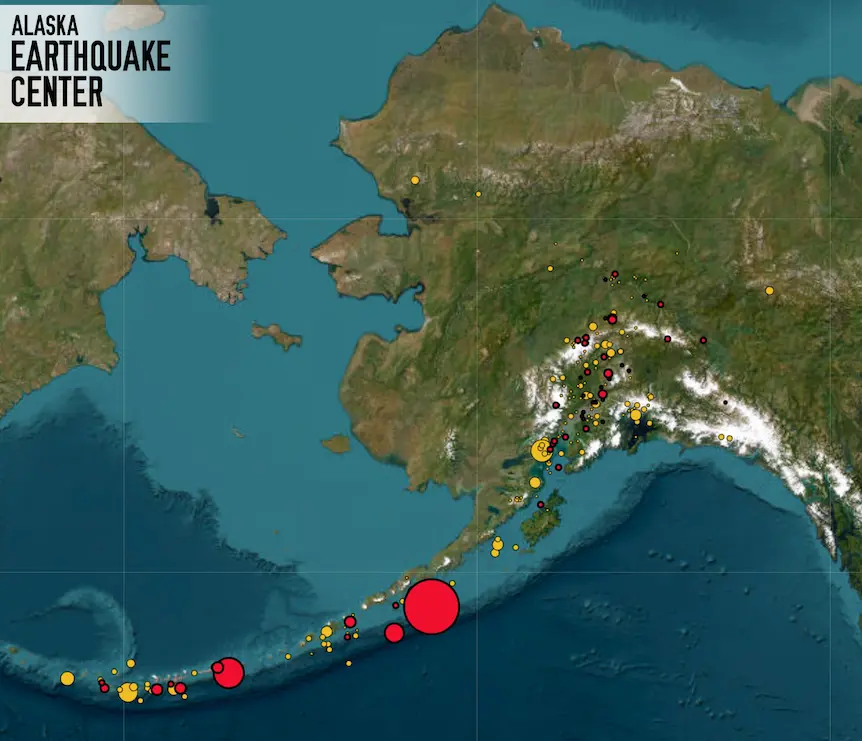
At 12:37 PM local time, the US Geological Survey (USGS) recorded a 7.3 magnitude earthquake approximately 87 kilometres south of Sand Point, a remote town on the Alaska Peninsula. The quake originated at a shallow depth of 20.1 km, amplifying its surface-level impact.
Residents in Kodiak, Cold Bay, King Cove, and Unalaska reported strong shaking. In Sand Point, pantry items flew off shelves, and emergency sirens blared as authorities ordered immediate evacuations. The quake was felt as far as Anchorage and Juneau, though with lighter intensity.
Within minutes, the National Tsunami Warning Centre issued a tsunami warning for coastal areas from Kennedy Entrance to Unimak Pass, covering hundreds of miles of shoreline. Water began receding along the coast—a classic precursor to tsunami waves, triggering panic and mass movement to higher ground.
Fortunately, after analysis from NOAA’s Deep-ocean Assessment and Reporting of Tsunamis (DART) system, the warning was downgraded to an advisory and later cancelled, as no significant waves were observed.
2. Why This Quake Matters: The Aleutian Megathrust & Ring of Fire
Alaska sits atop the Pacific Ring of Fire, one of the most seismically active zones on Earth. The region is home to the Alaska-Aleutian subduction system, where the Pacific Plate dives beneath the North American Plate—creating immense tectonic stress.
This quake is the fifth magnitude 7+ event in the same region since 2020, following the M7.8 Simeonof Earthquake in July 2020 and the M7.2 Sand Point quake in 2023. Experts believe the July 16 quake is part of a prolonged aftershock sequence, indicating heightened seismic activity.
According to NOAA:
- Earthquakes between 7.6 and 7.8 can generate destructive tsunamis near the epicenter.
- Shallow quakes like this one are more likely to cause vertical seabed displacement, a key trigger for tsunami formation.
While this quake didn’t produce a damaging tsunami, it served as a real-time drill for emergency systems and highlighted the importance of early warning infrastructure.
3. Community Response & Emergency Protocols
Local governments responded swiftly:
- Kodiak Police activated sirens and opened emergency shelters in schools.
- Residents in Sand Point, King Cove, and Cold Bay evacuated within minutes.
- The Alaska Earthquake Center detected over 40 aftershocks in the first three hours, the largest measuring 5.2 magnitude.
The USGS Aftershock Forecast warns that additional quakes—possibly above magnitude 6—are likely in the coming week. Communities remain on alert, with emergency drills and public advisories continuing.
Despite the scare, no fatalities or major structural damage have been reported. The USGS issued a Level GREEN alert, indicating low risk of casualties and economic loss.
4. Global Lessons: Preparedness in a Shifting World
This event underscores the global nature of seismic risk. As populations grow along coastlines, the social impact of earthquakes and tsunamis is expected to rise. Alaska’s response offers a blueprint for:
- Rapid evacuation protocols
- Real-time seismic monitoring
- Public education on tsunami behaviour
The quake also reignites conversations about urban resilience, especially in regions like Japan, Indonesia, and California, which share similar tectonic profiles.
For India, which faces its own seismic vulnerabilities in the Himalayan belt and Andaman region, Alaska’s experience is a reminder to invest in early warning systems, coastal evacuation planning, and community awareness.
Final Thoughts
The July 16 Alaska earthquake was more than a geological event, it was a stress test for humanity’s readiness. While the tsunami threat faded, the quake exposed the fragile balance between nature’s fury and our preparedness.
As aftershocks continue and scientists monitor fault lines, one truth remains: the earth doesn’t warn, it moves. And when it does, our only defense is knowledge, speed, and unity.
Stay updated with the latest news on Rapido Updates. Keep yourself updated with The World, India News, Entertainment, Market, Automobile, Gadgets, Sports, and many more
FAQ
What was the magnitude and location of the Alaska earthquake?
The earthquake measured 7.3 on the Richter scale and struck 54 miles south of Sand Point, located on the Alaska Peninsula. It occurred at a shallow depth of 20.1 km, making it more impactful on the surface.
Was a tsunami warning issued after the quake?
Yes. The National Tsunami Warning Center issued a tsunami warning for coastal areas from Kennedy Entrance to Unimak Pass, including cities like Kodiak, Cold Bay, and Sand Point. The warning was later downgraded to an advisory and eventually cancelled, as no significant waves were observed.
Were there any casualties or damage reported?
As of now, no fatalities or major structural damage have been reported. Residents experienced strong shaking, and emergency sirens were activated, but the region’s preparedness helped avoid disaster.
Is Alaska prone to earthquakes and tsunamis?
Absolutely. Alaska lies on the Pacific Ring of Fire and the Aleutian Megathrust, making it one of the most seismically active regions in the world. It has experienced five magnitude 7+ earthquakes in the same zone since 2020.
Are aftershocks expected following this earthquake?
Yes. The Alaska Earthquake Center detected over 40 aftershocks within the first three hours, with the largest measuring 5.2 magnitude. The USGS Aftershock Forecast warns that a magnitude 6 or greater aftershock is possible in the coming week.