
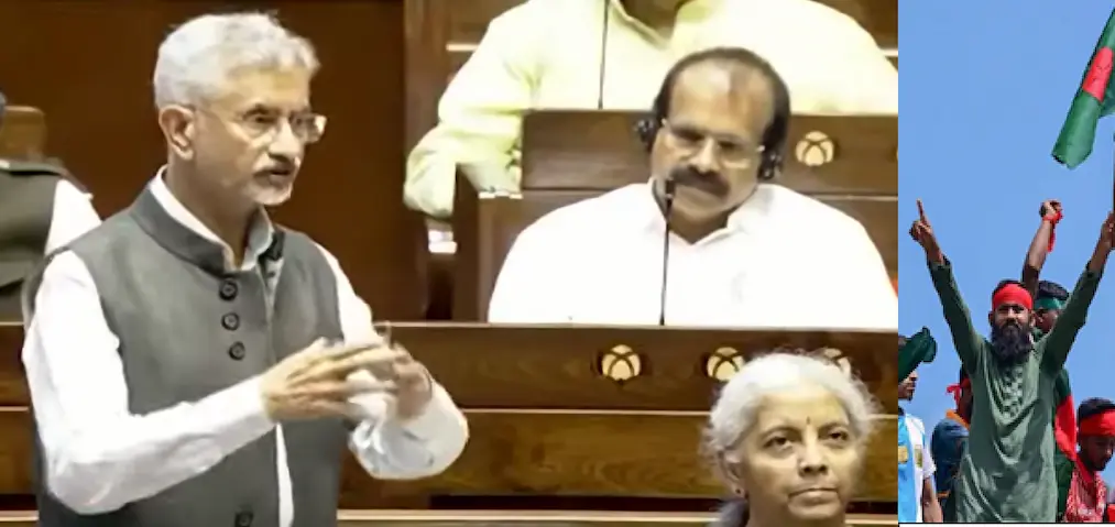
EAM S. Jaishankar addressed “The Government has taken note of reports… and is closely monitoring all developments that have implications for India’s national security.”
A Map That Sparked a Diplomatic Storm
In April 2025, a map surfaced at Dhaka University depicting a so-called “Greater Bangladesh”, an expanded vision of the country that controversially included large swathes of Indian territory. The map, allegedly promoted by an Islamist outfit named Saltanat-e-Bangla and reportedly backed by a Turkish NGO, ignited a firestorm of debate across South Asia. Indian officials, including External Affairs Minister S. Jaishankar, swiftly responded, raising concerns about national security, foreign influence, and ideological radicalism.
This blog unpacks the origins of the map, the truth behind the claims, and what it means for India, Bangladesh, and the broader geopolitical landscape.
What Is the “Greater Bangladesh” Map?
The map in question was displayed during an exhibition at Dhaka University on Pohela Baishakh (Bengali New Year), April 14, 2025. It portrayed a fictional Bangladesh that absorbed:
- India’s entire Northeast
- West Bengal
- Parts of Bihar, Jharkhand, and Odisha
- Myanmar’s Arakan region
The exhibition was reportedly themed around the Bengal Sultanate, a medieval Muslim kingdom that ruled parts of Eastern India and Bangladesh between the 14th and 16th centuries. Organizers claimed the map was a historical reference, not a political statement. However, its timing and content raised eyebrows.
Who Is Behind the Map?
The group allegedly responsible is Saltanat-e-Bangla, a Dhaka-based Islamist outfit with reported links to the Turkish Youth Federation, a non-governmental organization aligned with Turkey’s ruling AKP party. Indian intelligence agencies believe the group is part of a broader ideological push to revive Islamic identity politics in South Asia.
However, Bangladesh’s official fact-checking platform BanglaFact stated there is no evidence of Saltanat-e-Bangla being active in the country. Exhibition organizers also denied any affiliation with foreign political entities or radical agendas.
Ideological Roots: The Bengal Sultanate Revivalism
The term “Saltanat-e-Bangla” itself is derived from the Bengal Sultanate, which once ruled a vast region encompassing modern-day Bangladesh and parts of India. The revivalist narrative seeks to:
- Reclaim historical Islamic rule
- Promote pan-Bengali Muslim identity
- Challenge secular nationalism in Bangladesh
This ideology has gained traction among fringe groups, especially in the wake of political upheaval following the resignation of Prime Minister Sheikh Hasina in August 2024.
Political Context: Why Now?
The timing of the map’s appearance is critical. Bangladesh has been undergoing political turbulence:
- Sheikh Hasina, a pro-India leader, resigned and fled to India amid student-led protests
- Nobel laureate Muhammad Yunus took over as interim Prime Minister
- Rising anti-India sentiment fueled by accusations of Indian interference in Bangladeshi politics
This environment has created fertile ground for radical narratives, including the idea of a “Greater Bangladesh” that challenges India’s territorial integrity.
Disinformation or Provocation?
While the map was part of a historical exhibition, its viral spread on social media and lack of context led many to interpret it as a political statement. Indian media outlets and politicians raised alarms, suggesting:
- A coordinated attempt to undermine India’s sovereignty
- Foreign-backed ideological infiltration
- Potential links to Pakistan and Turkey’s strategic interests
However, fact-checkers and Bangladeshi officials maintain that the map was not part of any active separatist campaign, and the group behind it may not even exist in any formal capacity.
India’s Response: Strategic Vigilance
External Affairs Minister S. Jaishankar addressed the issue in Parliament, stating:
“The Government has taken note of reports… and is closely monitoring all developments that have implications for India’s national security.”
India has not confirmed any diplomatic engagement with Bangladesh or Turkey over the matter but has emphasized its commitment to safeguarding territorial integrity.
Turkey’s Role: Soft Power or Subversion?
Turkey’s growing influence in South Asia particularly through NGOs, religious outreach, and cultural diplomacy — has raised concerns. Under President Erdoğan’s neo-Ottoman foreign policy, Turkey has:
- Supported Islamist movements in Muslim-majority countries
- Expanded military and economic ties with Bangladesh
- Allegedly backed groups like Saltanat-e-Bangla to promote pan-Islamic identity
This soft power strategy could be seen as an attempt to counter India’s regional dominance and align Bangladesh with a broader Islamic bloc.
Security Implications for India
The map controversy, while seemingly symbolic, has real-world implications:
- Border Sensitivities: India’s Northeast is already vulnerable due to ethnic tensions and insurgencies
- Radicalization Risks: Ideological infiltration could destabilize border states
- Diplomatic Strain: India-Bangladesh ties may suffer if such provocations continue
India’s strategic community is now calling for:
- Enhanced intelligence cooperation
- Counter-disinformation campaigns
- Diplomatic engagement with Bangladesh’s interim government
Voices from Bangladesh: Mixed Reactions
While the Bangladeshi government distanced itself from the map, public opinion remains divided:
- Secular groups condemned the exhibition as irresponsible
- Islamist factions praised it as a revival of lost glory
- Youth activists questioned the role of foreign NGOs in shaping national identity
The incident has reignited debates over Bangladesh’s ideological direction, secular nationalism vs. Islamic revivalism.
The Truth Behind the Map
So, was the “Greater Bangladesh” map a genuine threat or a misunderstood historical reference?
Fact-checkers say:
- No verified Islamist group is actively promoting territorial expansion
- The map was part of a cultural exhibition, not a political manifesto
- Organizers denied any foreign influence
Indian officials say:
- The incident reflects deeper ideological currents
- Foreign-backed radicalism must be monitored
- National security cannot be compromised
Final Thoughts: Cartography as Ideology
Maps are powerful tools not just for navigation, but for shaping identity, history, and politics. The Greater Bangladesh map controversy reveals how historical nostalgia can be weaponized to provoke, polarize, and destabilize.
For India, the lesson is clear: vigilance must extend beyond borders to ideas. And for Bangladesh, the challenge is to balance cultural pride with geopolitical responsibility.
Also read – Turkey-Bangladesh Strategic Grip : A Rising Islamist Axis Threatening India’s Eastern Flank
India Airlifts 160 Illegal Bangladeshi Nationals from Ghaziabad to Agartala for Deportation